Image module

Political and economic position

of the Banda Islands before 1621 - Roy Ellen

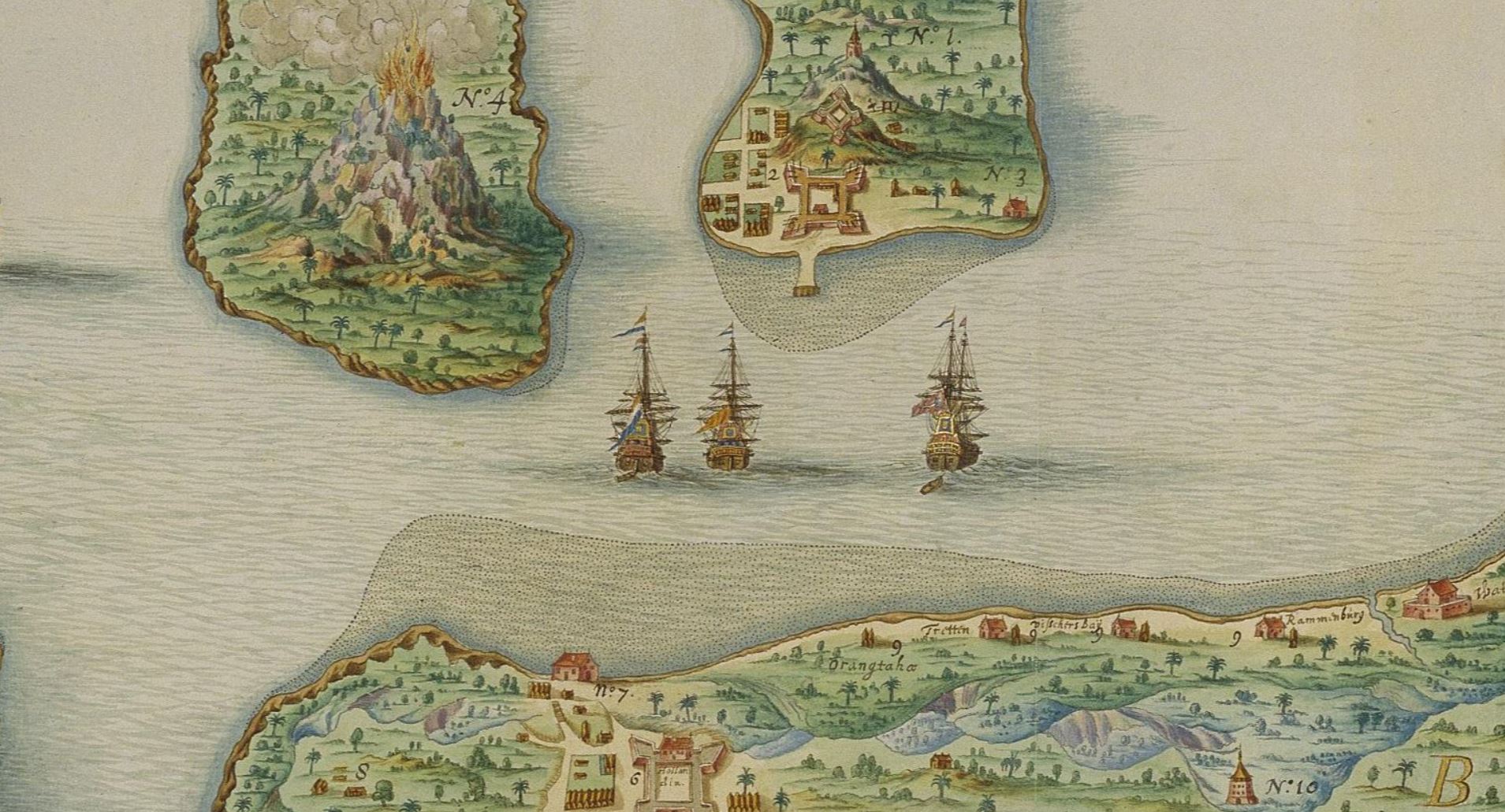
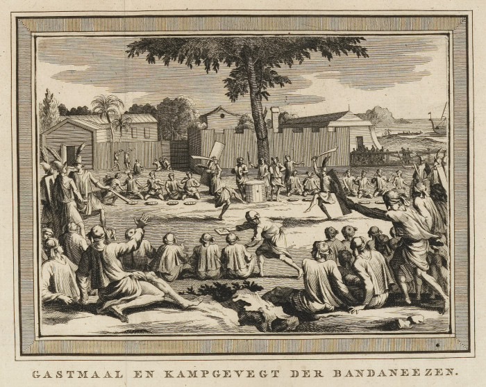
When the Dutch finally completed their subjugation of the Banda Islands under the leadership of Jan Pieterszoon Coen and massacred a large part of the indigenous population to ‘protect’ their colonial plantations, they destroyed a social and economic system then probably unique in island Southeast Asia.

Today it is difficult to provide much of the detail of what went before. However, from documentary sources, from what the remaining Bandanese and their successor populations committed to oral history and from what we can establish through archaeological, linguistic and ethnographic inference, it is possible to reconstruct something of that society and its position in the socio-ecological system of the Moluccas, as well as in the Asian world more generally. The documentary evidence is mainly what Europeans – Portuguese, Dutch and English in particular – had already written about Banda during the period of intermittent contact during the sixteenth century, and more particularly during the first two decades of the seventeenth century. There are also documents produced much later by the descendants of original Bandanese who fled to East Seram, as well as references in early Chinese, Javanese and other sources.

the spokes of a wheel

The properties of the Banda system before 1621 that were the key to its effective functioning, can only be understood through an examination of the ecology and geography of the islands themselves, as well as of their location in the context of eastern Indonesia more generally. The dynamics of seasonal trade, wind patterns, sea currents, and the position of the archipelago in relation to other surrounding island groups that were connected like spokes of a wheel, provided an underpinning that was integral to an early dependence on the economy of nutmeg production and the rise of Banda as a trading hub. Especially important were the connections between Banda and East Seram, in relation to the sea routes permitting access to the ports of Sulawesi and Java to the west, and China to the north. All this supported other causes, underlying the human motivation to exchange goods.

The Banda archipelago comprises both volcanic islands and islands formed through uplifted limestone. The inner group consists of Neira, Banda Besar (Lonthor), Pisang, Karaka and Gunung Api. The outer group consists of Hatta (Rozengain), Ai, Nailakka, Run and Manukan, plus some smaller islets. While the predominantly loose volcanic soils, good drainage and oceanic climate favoured nutmeg growth and productivity, the islands are otherwise agriculturally impoverished. Moreover, periodic eruption of the volcano on Gunung Api and seismic disturbance have been endemic throughout most of the historical period and there is little surface freshwater. There are records of prolonged drought, including in 1620; the year before the massacre. All of these factors have certainly limited human carrying capacity and terrestrial biodiversity and might be considered a disadvantage for somewhere so dependent on trade and spice production. The risks, however, need to be judged against other advantages: the location itself, its centrality in relation to other key trading places and some for the most part secure and safe harbours. Endemic volcanism was a problem faced by other spice-producing centres in the Moluccas, such as Ternate and Tidore, as were freshwater shortages and flooding in for instance East Seram, but these places were able to develop flexible short-term strategies to cope with the natural disasters that could be expected. Such strategies included temporary relocation and the security of inter-island exchange and political alliances. Their status as central places could thus be maintained over the longer term. Under modern conditions, with new kinds of permanent infrastructure and institutionalized state responses, this flexibility has declined.

Image module

This detail of a watercolour by Johannes Vingboons shows the two geological forces that shaped the Banda Islands: The Gunung Api volcano and the coral reefs. The ashes coming from the volcano made a fertile ground for growing nutmeg. The coral reefs shape the limestone of which most part of the islands consist of.


oldest relations

The archaeology of Banda  suggests that the earliest human occupation of the islands occurred around 3800-3200 BP, at least these are the oldest radiocarbon dates recovered from excavated ceramics. We also know from early historical reports that from the time of the earliest European contact until 1621, pottery was being produced in Banda and exported for example to Gorom off East Seram. Pottery that contained the distinctive Bandanese sand temper of volcanic ash. Given high levels of volcanic activity in Banda and no reports from Gorom and Aru, this is strong evidence for a movement of ceramics from Banda to the northeast and to the southeast. Such evidence already suggests a pre-existing cultural link with East Seram, but the most compelling evidence for such a link is linguistic.

Image module

Shard of ceramics with decorations made in the Banda Islands, c. 3200 BP, found at Pulau Ay. Courtesy of Peter Lape.

Both Old Bandanese and the Seram littoral language are derived from a tongue we can reconstruct as Proto-Banda, and thus linguistic indications are consistent with the geophysical linkage between East Seram and Banda, evident from sea currents and wind patterns. This suggests that the earliest human occupants of Banda arrived from the vicinity of East Seram before 3800 BP and possibly earlier. These facts also explain why East Seram, in addition to several places in the Kei islands, became a haven for refugees fleeing Banda in 1621. Indeed, as trading relations between Banda and east Seram were re-established after the massacre, so too were social relations between groups now residing in East Seram and the original Banda settlements from which they had fled. This relationship was couched in the language of Adat and involved the effective ‘reinvention’ of many traditions.

Image module

The east of the isle of Ceram. Below it the Banda Isles. From: Valentijn, Oud en Nieuw Oost Indiën. Collectie Koninklijke Bibliotheek, The Hague

earliest trade and commodities

The axis connecting Banda, archipelaic East Seram and from there the Papuan coast of New Guinea – the Banda-Onin corridor – was the key conduit stimulating the growth of the specialised trading economy of the Banda system. Both East Seram and Banda were key points in the commerce connecting the island of New Guinea to the rest of the world. For example, by the fifteenth century various tiny political domains in East Seram and Seram Laut, such as Kataloka, Kilwaru and Keffing, had long controlled access to and traded with extensive areas along the southern and western coast of New Guinea. At different periods in their history it would appear that different commodities dominated this trade. The earliest trade may have been in bird feathers – including those of the bird-of-paradise – as these feature on ancient bronze drums found in the region. Indeed, the legal and illegal trade in bird feathers has continued through the Banda islands up to the present. This is reflected in the use of imported feathers from New Guinea in ceremonial Bandanese headgear even today.

However, the commodity that proved transformative was undoubtedly nutmeg (Myristica), both the hard seed itself and the dried aril known as mace. There are several ‘wild’ species of this genus found in the forests of New Guinea and parts of the Moluccas, which produce fruit that is sometimes harvested and occasionally planted and traded. Round nutmeg (Myristica fragans) had been traded with India and the Mediterranean since at least the first millennium BCE and with China since perhaps the fifth and sixth centuries CE. A different species of long nutmeg (Myristica argentea) may well have been the earliest to be traded westwards from New Guinea and is still grown on Gorom and surrounding islands from where it is exported. However, it was the appearance of round nutmeg, grown in managed groves, that was to change the economy of Banda. Various varieties of this round nutmeg were preferred over the long nutmeg in the China, Indian and European trade, and this stimulated further development of nutmeg estates.

Image module

Nutmeg (coll. British Library, London)

a specialized economy

As the indigenous Bandanese nutmeg estates grew, they displaced the local capacity for subsistence production. The Bandanese had to rely increasingly on imported food and other products coming from East Seram and Seram Laut, Aru, the Kei islands and elsewhere along the various spokes of the Bandanese trading wheel. The products imported included especially sago starch (Metroxylon sagu) and sago palm leafstalks and thatch for dwellings. By the time the first Europeans arrived, most of the archipelago was covered in nutmeg groves, to the exclusion of almost every other form of productive land use. Only nanari trees (Canarium indicum) were interspersed among the nutmeg, providing shade, valuable proteinaceous nuts and oil. Unlike other parts of the Moluccas, where coconut palms were a widely used source of cooking oil, their relative shortage on Banda and the large number of nanari encouraged extraction of oil from this species as well as from nutmeg. The rest of the economy was oriented towards the sea: fishing for both subsistence and exchange, and the entrepôt trade.

How was this specialized economy with its pivotal role for Banda achieved socially and politically? Clearly, the advantages of being a central place with harbours for trade, as well as the favourable conditions as a habitat for nutmeg, were significant. Remarkable, however, is that the production and trading infrastructure came about not through the emergence of a centralized polity. Banda was not a state, nor were its comprising polities. It never claimed territory, nor exercised conventional political control over other peoples or resources, other than slaves.  There were no sultanates of the kind that emerged in the north Moluccas along the lines of Ternate and Tidore with a controlling single power. Rather everything operated through a distributed system of power, split between a number of small political domains. The domains were essentially independent with no island-wide or archipelagic federation. Although there were periodic feuds between domains involving head-taking, they could also combine to achieve various common purposes. Domains were linked, however, to fraternal polities in other parts of the Moluccas, most particularly with those of East Seram through membership of the Uli Fito (‘Seven’), Uli Siwa (‘Nine’) and Uli Lima (‘Five’) confederacies. Symbolic groupings, based on shared customary practices and alliance. These confederacies were ritually revitalized from time-to-time and activated in response to natural disasters and conflict and in support of trade. Although the sultans of Ternate claimed to wield power over Banda at various times and some Bandanese domains appear to have offered periodic tribute, this was never translated into effective control.

Image module

Festivities on Banda with groups of allies (coll. Atlas van Stolk, Rotterdam)

gatekeepers and middlemen

At the time of the first direct contact with the West the Bandanese domains included Labetaka (Lautaka) and Neira on Neira island, Lonthor, Orantatta, Ratu, Kombir, Selamon, possibly Dender, Waer, Lautung and Uring and Ai, Run and Rozengain on separate islands. However, it is not easy to calculate the number of domains, or to separate the names of domains from those of physical settlements. Neither domains nor settlements were of equal size or political significance. Moreover, their importance may have shifted over time. For example, by 1601 Neira appears to have superseded Lonthor in importance as a trading centre.
Each domain was ruled through what were called in Malay orang kaya, elder males who had serviceable political connections with places on the Bandanese trading hub. They were also gatekeepers to other ‘ports of trade’ between Banda and the Malay peninsula. As middlemen, the orang kaya were able to control the means of exchange and production and especially had the power to organize the export trade. In this they were supported by subservient syahbandars (harbour masters). In the early seventeenth century these are reported for Labetaka, Neira, Lonthor, Orantatta, Ratu, Kombir, Run and Ai. Some domains also maintained agents elsewhere, for example in Makassar and Malacca, while Makassar had agents in Banda. At times the various domains appear to have been in constant warfare with each other, but at other times they maintained sufficiently good relations to cooperate in common interests related to trade and outsiders.

Image module

 Bandanese playing a ball game (From ‘De tweede schipvaart der Nederlanders naar Oost-Indie onder Jacob Cornelisz.van Neck en Wybrant Warwijck, 1598-1600’ (coll. Rijksmuseum)

kings nor lords

Although, as António de Brito observed in 1522, ‘they had neither kings nor lords’, it is doubtful that the characterization of Bandanese domains as village republics and their leaders as some kind of mercantile aristocracy, as suggested by some scholars, is entirely accurate. For one thing, there always seem to be more orang kaya than domains or settlements mentioned in the European sources, with inconsistent references to their numbers. A more plausible explanation is that orang kaya were drawn from both the heads of domains and from among the clan chiefs, in a way similar to the matlaen of East Seram at the same time and since. Some chiefs were thus able to enrich themselves through trade by virtue of their traditional authority, rather than being merchants who came to occupy a position of political influence. The more important may have bolstered their position through conversion to Islam or through intermarriage between local women of the ruling clans with incoming traders from Java or elsewhere. This pattern would be more in line with what we know of traditional political systems in the Central Moluccas and especially the small independent polities around the tip of East Seram and Seram Laut. These were able to exercise commercial power beyond their size, by virtue of their geographic position and ability to control the trade between the periphery of New Guinea and points further west. The ambiguity of the term orang kaya has been compounded by its adoption as an official title in a system of ranks in parts of the Moluccas during the time of the VOC and the later colonial period.

On basis of the East Seram model, each Bandanese polity would have been comprised of a number of intermarrying, exogamous, patrinlineal land-holding clans or houses. We know that each domain had a council of elders, presumably with representatives from the different clans. These councils existed to organize ceremonies, manage rights to nutmeg groves and the planting of nanari and to maintain mosques and possibly inshore fishing rights. Attached to each clan were slaves, mainly imported through links with East Seram (from Papua) and the Aru islands. There is evidence that the heads of wealthy clans would have also intermarried with clans from elsewhere, particularly those of the East Seram domains. Some of the Bandanese domains, clans and settlements from before 1621 survive to this day in the names of descent groups in East Seram, such as Kotabanda, Rumadan, Kasongat, Namasawar and Soleman.

Image module

Already in the 16th century the Portuguese were on Banda. Here  Egeron, leader of Banda, is captured by the Portuguese (coll. Atlas van Stolk, Rotterdam). Etching by Reinier Vinkeles in De Hollandse Natie, 4e zang van  Jan Frederik Helmers

the Banda Sea network

In this way the archipelago served to articulate trade over a vast area around the Banda Sea. Its increasing specialization in nutmeg production led to a corresponding increase in its dependence on the import of food and other resources. Although, as Antonio Pigafetta tells us, the outer islands may have provided the central islands with some sago, most was imported from East Seram, Seram Laut, Gorom, Kei, Aru and possibly New Guinea. Indeed, for the Portuguese apothecary and diplomat Tomé Pires, sago was ‘a kind of currency’. Banda also imported dried fish and salt from other parts of the Banda Sea network and rice from Java and Bali. In addition timber was shipped from the periphery, especially to support the ship-building industry. There was also a trade in slaves and people from the periphery came to Banda to buy cloth, gold, cotton and iron goods, which had been in turn imported from the western Indonesian archipelago. These latter goods included batiks from Java, calico from India, porcelain from China and gongs and metal ware from Bali. There was also a small entrepôt trade in cloves from the north Moluccas.

Image module

The production of sago flour along a river on the south coast of Seram. Sago palms in the background. As the Banda Islands became fully specialized in nutmeg production, they had to rely on trade with other islands for their food supply. Image: Ulet Ifansasti/CIFOR

Image module

The sago palm as depicted in the manuscript of Rumphius’ Kruidboek. Collection Leiden University.

Compared with other peoples of the Moluccas, boat-builders in sixteenth- and early seventeenth-century Banda constructed large vessels for commerce, as well as sizeable double outrigger canoes (kora-kora), used in warfare. They navigated extensively throughout island Southeast Asia, sailing to Makassar, Java and as far west as Johore and Malacca. They were, therefore, far from being completely dependent on boats coming from Sulawesi, Java or the Malay peninsula. Bandanese vessels carrying exports, sailed on the east monsoon (in April) via the south coast of Sulawesi to ports on the north coast of Java. They returned on the west monsoon (May-June) via the north coast of Bali and Nusa Tenngara to Timor and then up to Banda. A lambo, a sailing boat with a European rig, woud in the 1980s take 14 days from Banda to Surabaya downwind. It is unlikely that before the seventeenth century vessels took any longer.

Image module

The cora-cora, vessel used by the Bandanese for trade and war (coll. Rijksmuseum, Amsterdam)

international and dynamic

The fact that the name Banda (Wandan) probably derives from the Persian term meaning emporium, while pala (nutmeg) is from Sanskrit, suggests a long association between the islands and international trade over a wide area. The traders the Europeans encountered, when they first arrived on Banda, included Javanese, Buginese, Malay, Chinese and Arabs. Although patterns of direct contact with traders of different backgrounds no doubt shifted from the time of the earliest evidence for the nutmeg trade. Chinese pottery has been found in layers dated to 500–770 CE on Neira, and more regularly in Banda assemblages in post-tenth century contexts. This may reflect growth in the China trade and maybe also direct Chinese contact between the twelfth and fifteenth centuries. By the sixteenth century there is lots of Chinese, Vietnamese and Thai ware. After 1600, on the evidence of the archaeology, imported ceramics outnumber locally made earthenware. Certainly, the fifteenth and sixteenth centuries were a period of change, in part reflected in the appearance of coastal and fortified mountain settlements, and of walled compounds on Neira.

By the late fifteenth century the first Arab traders appear. It is likely that though many Bandanese at this time were Muslim, particularly orang kaya and syahbandar, a few settlements had become Muslim enclaves much earlier. However, when the Europeans arrived, the sources are very clear that there were still many practicing animists and that many Muslims continued with animist customs. Labataka on Banda Besar, for example, was still likely a non-Muslim domain. Pig bone and cremated human remains from several sites suggest animists, while the disappearance of pig bone in the late sixteenth century suggests their absence. Islamization was obviously a consequence of long-distance trade to the west and of global demand for nutmeg and other products found in the Banda zone, but so was the ethnic diversity of the resident community of traders. By 1609 the population comprised as many non-Bandanese as Bandanese inhabitants: other Moluccans, Indians, Malays, Chinese and above all some 1500 Javanese merchants. Indeed, the Dutch described Neira as being essentially Javanese. Although the presence of Europeans was new, there is now sufficient archaeological and historical evidence to support the claim that rather than being homogenous and culturally static, Banda had for several millennia been a ‘dynamic society in a zone of culture contact’ (Lape), much affected by early contact with international traders.

trading partners and contracts

Long-distance trade with the Near East, the Mediterranean and China had therefore impacted the nutmeg and clove producing areas of the Moluccas since ancient times, fundamentally transforming them. When the first European traders arrived in 1512 in the form of Antonio de Abreu and the Portuguese, their presence initially caused little disruption to existing trading relations. The Portuguese had no permanent base and the Bandanese continued to produce and market nutmeg with little outside interference. They preferred Asians as trading partners, who were used to a style of negotiation that involved bargaining over individual transactions rather than contracts that committed them over the long term. Although the Bandanese were openly hostile towards the Portuguese, such arrangements were actually better suited to the Portuguese than they were later to the Dutch. But the price of nutmeg and mace grew exponentially as the spices moved westwards, while European profit incentives for cutting out Asian middlemen were high. When Malacca fell to the Portuguese in 1511, there was a resulting de-stabilization in the trade in spices and the sixteenth century saw increasing political volatility. In the Moluccas there was an alliance between the Banda polities and Ternate from about 1570 to counter European incursions.
When the Dutch under the command of Jacob van Heemskerck first appeared in Banda, they encountered a system in which hundreds of individual vendors marketed small quantities of nutmeg and mace. This they found difficult to manage. They therefore resolved to put trade on a more commercial footing, in a way that advantaged the Dutch East India Company (VOC) over the interests of both Asian and other European merchants. Dutch traders were frustrated by price fluctuations, issues around weights and measures, fraud and quality control, and for this reason tended to buy mostly from Chinese and Arab intermediaries. By 1602 the Dutch had secured a monopoly contract with some orang kaya, only to disappear for a period of years. When they returned in 1605 the contract was renewed and a more permanent presence established, with resident factors, storehouses and dwellings later converted into a fortified and garrisoned compound on Neira. By this time the Portuguese were effectively out of the picture. Traders from the English East India Company had established themselves on Ai in 1601 and afterwards on Run. Commercial rivalry, followed by outright conflict, ensued between first the Dutch and Bandanese (more consequentially for the Bandanese themselves), and then (much more consequentially in global terms) between the English and the Dutch.

Image module

The tradingpost from which the Dutch traded on Banda Neira. From ‘De tweede schipvaart der Nederlanders naar Oost-Indie onder Jacob Cornelisz.van Neck en Wybrant Warwijck, 1598-1600’ (coll. Rijksmuseum)

destroyed and recreated

Ultimately, the failure of the Bandanese to honour the terms of their contracts in the way the Dutch expected and required, widespread indebtedness and attacks on the settlement on Neira, led in 1621 to a Dutch revenge attack. Between 44 and 48 orang kaya were murdered (the figure seems to vary depending on the source) and of the general population many fled to Makassar, Kei, Aru, East Seram, Seram Laut and elsewhere. Of a total indigenous population of 15,000 people, barely 1000 survived, probably mainly women and children and those located in the more inaccessible outer islands. Allies in Seram Laut sent a flotilla of kora-kora to Banda in 1624 to evacuate the remaining indigenous population. Although a few Bandanese remained or were in subsequent years forcibly returned from Batavia and Makassar, the Dutch were faced with recreating a functioning society that would serve their interests in acquiring nutmeg. In order to do this they had, effectively, to recreate the system they had destroyed. Starved of food and other resources to support the new population and a landscape dominated by nutmeg estates, the Dutch needed to harness the dynamic of the Banda system again to supply the needs of the colony. This required, amongst other things, mending relations with East Seram sufficiently to restore the supply of sago. So, even after the Dutch conquest, Banda can only be understood in relation to the wider regional traditional system of which it had become the pivot. Fortunately, its environmental fragility was outweighed by its importance as a central place and in particular in relation to East Seram. It is ironical that during the nineteenth century the then Banda Residency absorbed East Seram and its surrounding islands into its administrative remit, thus re-uniting Banda with its cultural and economic sibling.

Image module

‘Perk’ on Banda, a drawing by QMR VerHuell (coll. Maritime Museum Rotterdam).